Direct interstate access
Located along I-5 at the Utica Avenue interchange.
At the Utica Avenue interchange in Kings County, Jackson Ranch connects directly to California’s principal north-south interstate corridor.
View the interchange on Google MapsA continuous aerial pass over the planned campus, 2 minutes 36 seconds long, with no sound. It crosses the industrial blocks and their truck courts, the highway commercial area at the Interstate 5 interchange with its hotel, restaurant and quick-service parcels around the central green space, the truck stop and fuel parcels on Utica Avenue, and the specialty agriculture beyond the campus.
Project location: Kings County via CEQAnet. Highway alignment: Caltrans. State boundary and city reference points: U.S. Census Bureau. San Francisco: OpenStreetMap contributors.
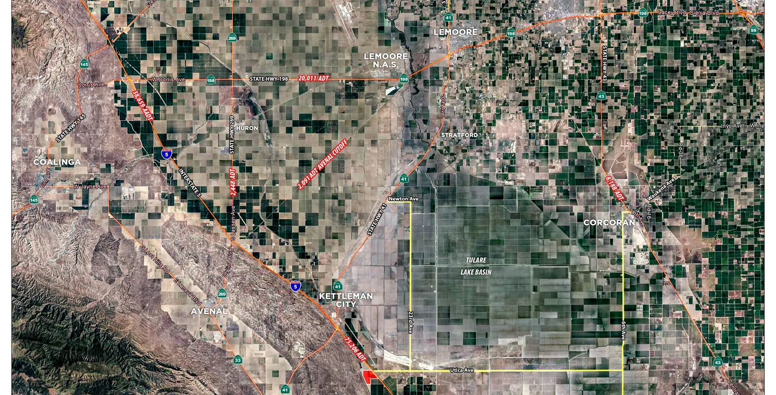
Kings County lies in California's Central San Joaquin Valley, approximately midway between San Francisco and Los Angeles. Its population of approximately 154,000 is anchored by Hanford, Lemoore, Corcoran, Avenal and Kettleman City, and its economy by agriculture, food processing, manufacturing, logistics and distribution, with emerging opportunities in renewable energy and advanced manufacturing. The Kings County Job Training Office offers employers hiring incentives.
The site is on Interstate 5, California's primary north-south freight corridor. The area is served by the BNSF and San Joaquin Valley Railroad freight networks; Fresno International Airport is approximately 58 miles away and Bakersfield approximately 77. The Ports of Stockton, Oakland, Los Angeles and Long Beach are reached by the regional highway network.
Source: Jackson Ranch offering memorandum, October 2026.
Positioned between Northern and Southern California, the site offers a platform for serving regional industrial markets, distribution networks and major population centers.
Explore the campus planLocated along I-5 at the Utica Avenue interchange.
Access to the Bay Area, Greater Los Angeles and Central Valley markets via the interstate network.
An approved, illuminated 100-foot pylon sign at the interchange, with eight larger tenant panels above six smaller ones.
See the sign design75,206 Average daily traffic, Interstate 5 At Utica Avenue, the property’s interchange
| Route | Average daily traffic | Where |
|---|---|---|
| Interstate 5 | 38,659 | North of the site, towards Coalinga |
| State Highway 198 | 20,011 | East towards Lemoore and Hanford |
| State Highway 43 | 8,188 | East of the Tulare Lake basin |
| State Highway 269 | 2,448 | North towards Huron |
| Avenal Cutoff | 2,091 | West towards Avenal |
Source: Kalibrate TrafficMetrix and STI.
| Measure | 15 minutes | 30 minutes | 45 minutes |
|---|---|---|---|
| Businesses | 56 | 413 | 3,700 |
| Employees | 765 | 5,618 | 64,933 |
| Population | 1,219 | 29,328 | 165,272 |
| Employees per 100 residents Employees working in the area for every 100 people living there. | 62.8 | 19.2 | 39.3 |
2026 counts inside 15-, 30- and 45-minute drive-time areas. The areas are a model rather than a measurement, which is why road distances are published separately below. Source: Jackson Ranch offering memorandum, October 2026.
CalVans runs work-commute vanpools across the region, with documented activity serving Avenal, Corcoran and Hanford. Existing Kettleman City businesses, among them restaurants, gas stations and Bravo Farms, already draw employees from Avenal, Corcoran and Lemoore.
Source: Jackson Ranch offering memorandum, October 2026.
| Destination | Road distance |
|---|---|
| Port of OaklandNorthern California port access. | 205 mi |
| Ports of LA / Long BeachSouthern California port access. Measured to the Port of Long Beach. | 190 mi |
| Inland EmpireRegional distribution market. Measured to Ontario. | 205 mi |
| San Francisco Bay AreaNamed on the regional locator. Measured to San Francisco. | 215 mi |
| SacramentoNorthern Central Valley market. | 215 mi |
Approximate road distances by the fastest highway route from the Interstate 5 and Utica Avenue interchange, rounded to the nearest five miles. Source: OpenStreetMap contributors.
40M+ People within a one-day drive of the property
Approximate drive times from the property. Source: Jackson Ranch offering memorandum, October 2026.
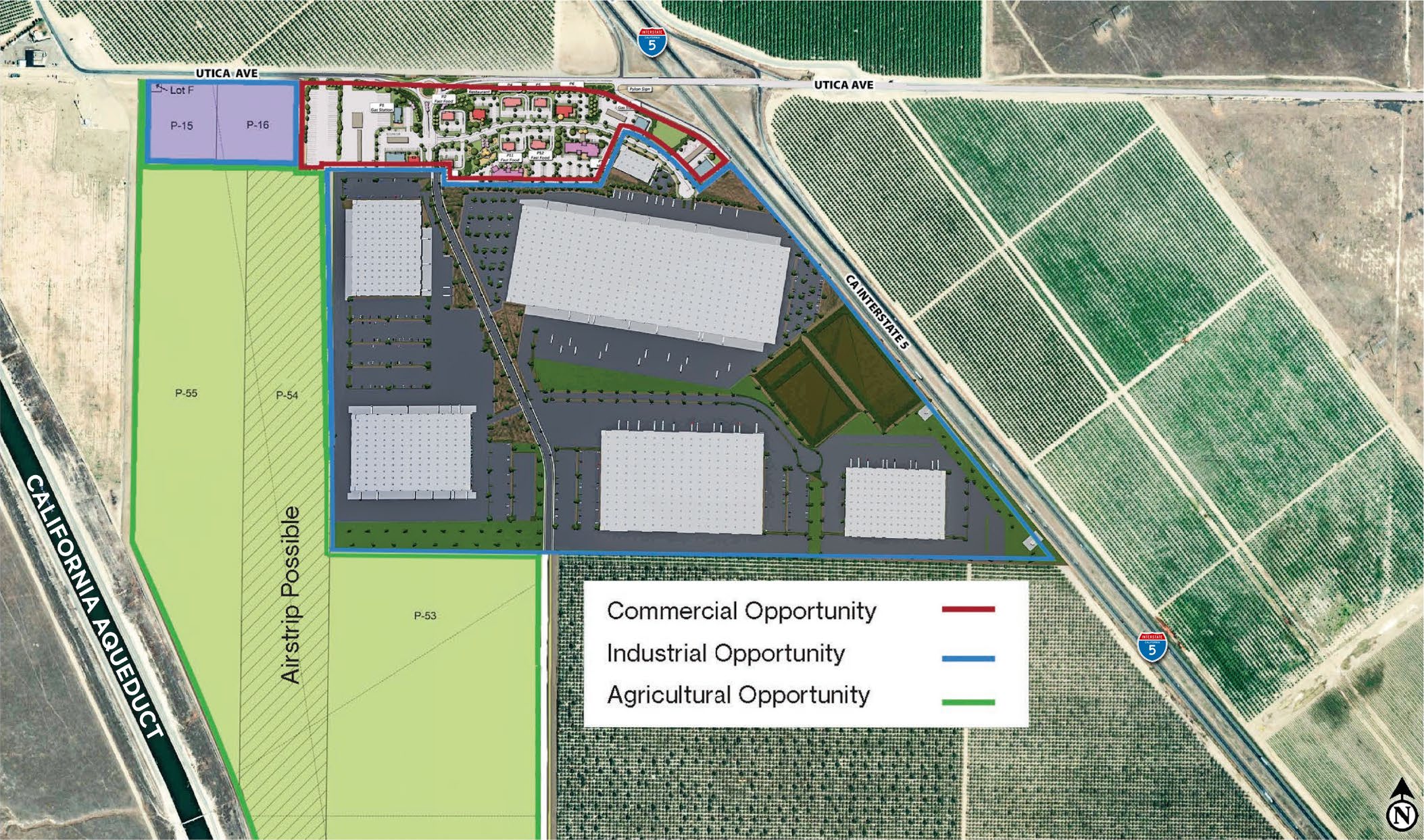
The approximately 138-acre industrial offering, 119.46 acres of it net buildable, is part of the broader 415-acre campus, alongside 27 acres of highway commercial land and the campus's agricultural, expansion and solar fields.
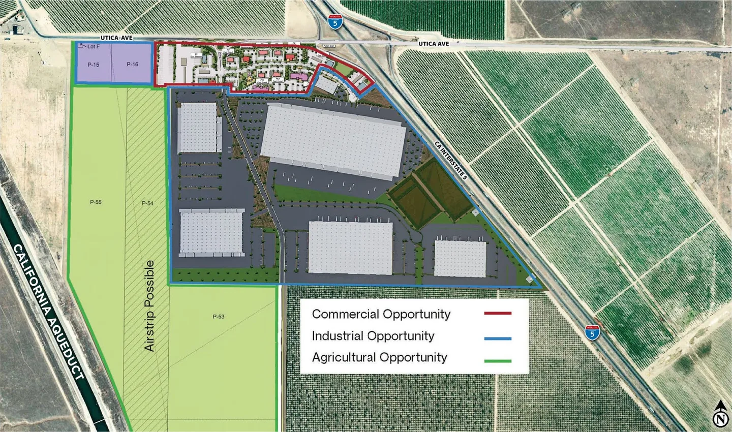
A 10.03-acre truck stop, now sold, with truck and trailer parking, fleet support, fuel, convenience and hospitality uses.
Proposed restaurants, retail and services for employees, businesses and visitors.
A 0.90-acre green space amenity at the centre of the commercial area, for travellers and for the people working here.
207 acres planned for renewable energy, with proposed solar generation to support campus operations, alongside commercial-truck and passenger-vehicle EV charging. Subject to feasibility and utility confirmation.
West of the industrial area, the agricultural, expansion and solar fields run to the California Aqueduct, with 207 acres planned for renewable energy. The land use plan marks an airstrip as possible on one of those parcels.
These are planned and proposed components, not representations of completed amenities or committed utility capacity. Property address: 25545 Utica Ave, Kettleman City, CA 93239.
Prepare a draft now, then call or email Roy Belson to arrange a first call.